
Jeannie And Gary's Guidebook
Close by Breakfast & lunch Cafe
Bobby’s is a small town cafe that serves comfort food from 8am to 3pm. No frills, but good food!
A short 5 minute drive north from our house to the next Peters Creek (2.1 Miles)
6 lokalinvånare rekommenderar

Bobby's Cafe'
20900 Bill Stephens DrBobby’s is a small town cafe that serves comfort food from 8am to 3pm. No frills, but good food!
A short 5 minute drive north from our house to the next Peters Creek (2.1 Miles)
Cozy Italian Dinner restaurant
Nice Italian and American food restaurant that opens @ 4pm shortly after Bobby’s (next door) closes.
A short 5 minute drive (2.1 mile) north from our house to the next peters creek exit.
10 lokalinvånare rekommenderar
Bella Vista Pizzeria
20908 Bill Stephens DrNice Italian and American food restaurant that opens @ 4pm shortly after Bobby’s (next door) closes.
A short 5 minute drive (2.1 mile) north from our house to the next peters creek exit.
Local hiking trails
Who can say no to a cool waterfall only a half-hour’s drive from town?
One of the most popular “first hikes” for families with small children, the one-mile trail to Thunderbird Falls traverses a handsome birch forest along the Eklutna River canyon to reach a deck with views of a 200-foot waterfall.
Located inside Chugach State Park north of Eagle River and just south of Eklutna, the trail climbs steeply at first, gaining about 100 feet in elevation. Then the route levels out and becomes an easy walk.
A viewing deck, refurbished in the past few years, offers an elevated straight-on view. But the more adventuresome will want to take a side trail down into the canyon. With some care for footing, you can work upstream to the base of the falls and feel the chilly spray of Thunderbird Creek on your face.
During winter, the falls can freeze, forming fabulous columns of blue ice. Take care that you have ice grippers on shoes after temperatures plunge. In all seasons, parents will want to be wary of the canyon lip and keep children well away.
https://www.alaska.org/detail/thunderbird-falls-trail
80 lokalinvånare rekommenderar
Thunderbird Falls
25321 Old Glenn HighwayWho can say no to a cool waterfall only a half-hour’s drive from town?
One of the most popular “first hikes” for families with small children, the one-mile trail to Thunderbird Falls traverses a handsome birch forest along the Eklutna River canyon to reach a deck with views of a 200-foot waterfall.
Located inside Chugach State Park north of Eagle River and just south of Eklutna, the trail climbs steeply at first, gaining about 100 feet in elevation. Then the route levels out and becomes an easy walk.
A viewing deck, refurbished in the past few years, offers an elevated straight-on view. But the more adventuresome will want to take a side trail down into the canyon. With some care for footing, you can work upstream to the base of the falls and feel the chilly spray of Thunderbird Creek on your face.
During winter, the falls can freeze, forming fabulous columns of blue ice. Take care that you have ice grippers on shoes after temperatures plunge. In all seasons, parents will want to be wary of the canyon lip and keep children well away.
https://www.alaska.org/detail/thunderbird-falls-trail
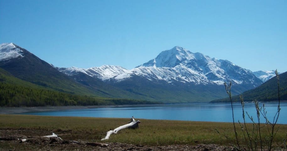
A short 11 mile drive north toward palmer is this one-mile trail around Reflections Lake offers easy walking year-round. Come with snowshoes, skis, or ice skates during the winter months, or identify wildflowers and forest birds in summer. Mostly wooded, the trail does open up to views of the surrounding mountains at one end of the lake, where the large forest gives way to smaller trees and grasses. Dawn and dusk here can be stunning, with sunset colors playing across the water and on the peaks. If you have a canoe or kayak, you can carry it down to the lake for a fun, sheltered paddle.
https://www.alaska.org/detail/reflections-lake-trail
9 lokalinvånare rekommenderar
Reflections Lake
A short 11 mile drive north toward palmer is this one-mile trail around Reflections Lake offers easy walking year-round. Come with snowshoes, skis, or ice skates during the winter months, or identify wildflowers and forest birds in summer. Mostly wooded, the trail does open up to views of the surrounding mountains at one end of the lake, where the large forest gives way to smaller trees and grasses. Dawn and dusk here can be stunning, with sunset colors playing across the water and on the peaks. If you have a canoe or kayak, you can carry it down to the lake for a fun, sheltered paddle.
https://www.alaska.org/detail/reflections-lake-trail
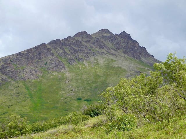
A little further south in the heart of Eagle River (about 20 miles away) is Mt Baldy Trail. Moderate 1-2 hour hike - a local favorite.
Baldy is a popular day hike overlooking Eagle River. Baldy is appropriately named; the top is a round, bare mountaintop. The trail starts from a parking lot at the base. A radio antenna is located just a few hundred feet or so from the start of the trail. From there it winds through trees and scrub until it eventually reaches the real base of the mountain. Once above the plant growth, it starts to climb moderately through somewhat rocky terrain. From the top, one can see a good view of Eagle River Valley and the surrounding mountains.
Important Information: Bug spray is a plus and The trail can be somewhat muddy early in the season.
Baldy is not only a great day hike, it's the starting point for many other peaks, including Black Tail Rocks, Round Top, and Vista peaks.
The trailhead is at the top of Skyline Drive in Eagle River. A new parking area was built in 2009 that can accommodate many more vehicles than previously.
https://alaskahikesearch.com/hikes/mt-baldy/
39 lokalinvånare rekommenderar
Mt. Baldy Trailhead
12900 Golden Eagle DrA little further south in the heart of Eagle River (about 20 miles away) is Mt Baldy Trail. Moderate 1-2 hour hike - a local favorite.
Baldy is a popular day hike overlooking Eagle River. Baldy is appropriately named; the top is a round, bare mountaintop. The trail starts from a parking lot at the base. A radio antenna is located just a few hundred feet or so from the start of the trail. From there it winds through trees and scrub until it eventually reaches the real base of the mountain. Once above the plant growth, it starts to climb moderately through somewhat rocky terrain. From the top, one can see a good view of Eagle River Valley and the surrounding mountains.
Important Information: Bug spray is a plus and The trail can be somewhat muddy early in the season.
Baldy is not only a great day hike, it's the starting point for many other peaks, including Black Tail Rocks, Round Top, and Vista peaks.
The trailhead is at the top of Skyline Drive in Eagle River. A new parking area was built in 2009 that can accommodate many more vehicles than previously.
https://alaskahikesearch.com/hikes/mt-baldy/
This 10.8-mile out-and-back trail near Chugiak, Alaska. Generally considered a challenging route, it takes an average of 6 h 20 min to complete. This is a popular trail for cross-country skiing, hiking, and snowshoeing, but you can still enjoy some solitude during quieter times of day. The best times to visit this trail are June through August. Dogs are welcome, but must be on a leash. And don’t forget the bug spray.. Mosquitos outnumber the humans about 6500 to 1.
https://www.alltrails.com/trail/us/alaska/ptarmigan-valley-trail
Ptarmigan Valley Trailhead
18845 Old Glenn HwyThis 10.8-mile out-and-back trail near Chugiak, Alaska. Generally considered a challenging route, it takes an average of 6 h 20 min to complete. This is a popular trail for cross-country skiing, hiking, and snowshoeing, but you can still enjoy some solitude during quieter times of day. The best times to visit this trail are June through August. Dogs are welcome, but must be on a leash. And don’t forget the bug spray.. Mosquitos outnumber the humans about 6500 to 1.
https://www.alltrails.com/trail/us/alaska/ptarmigan-valley-trail
Quote from https://weheartalaska.blogspot.com/2016/08/mile-hi-saddl.html “The trail that goes through the birch forest is tilted to one side so wear good, supportive shoes. I imagine if the trail gets wet footing would be very difficult. It is also a relentlessly "up" trail. There's a little bit of a break when you hit the saddle but then it's right back to walking right up a mountain. Once you get to the saddle you can hike up the mountain to your right (Iron Nipple, those who have seen this mountain from downtown Eagle River will instantly know which one this is) or to your left, Mt. Tucker. Going straight heads to Mt. Magnificent which was a little too much for us to take on that day. I wish we would have picked Iron Nipple but we decided on Mt. Tucker. We didn't get to the top but we found a LOT of blueberries. No complaints.”
Take Eagle River Road just past the Mile 3 mile marker and look for Mile High road on the right. The road changes names as it swithches back and forth, but always take the turn going up and eventually you will see a small turnout on the right at Beaver Road. The trail is just past the gate, to the left of the attenna towers. The trail goes up for a short distance and then joins with the original trail which is more direct but it crosses private property. Continue up, and when you get to the saddle, you can turn right onto the Mt. Magnificant Trail to follow the ridge that ends at the mountain, or left continuing along the original trail. The trail offers nice views of Cook Inlet and even Denali on a clear day.
https://www.adn.com/outdoors-adventure/2016/07/26/short-and-sweet-mile-high-saddle-in-eagle-river-delivers-magnificent-views/
Mile High Trailhead
Brownie DriveQuote from https://weheartalaska.blogspot.com/2016/08/mile-hi-saddl.html “The trail that goes through the birch forest is tilted to one side so wear good, supportive shoes. I imagine if the trail gets wet footing would be very difficult. It is also a relentlessly "up" trail. There's a little bit of a break when you hit the saddle but then it's right back to walking right up a mountain. Once you get to the saddle you can hike up the mountain to your right (Iron Nipple, those who have seen this mountain from downtown Eagle River will instantly know which one this is) or to your left, Mt. Tucker. Going straight heads to Mt. Magnificent which was a little too much for us to take on that day. I wish we would have picked Iron Nipple but we decided on Mt. Tucker. We didn't get to the top but we found a LOT of blueberries. No complaints.”
Take Eagle River Road just past the Mile 3 mile marker and look for Mile High road on the right. The road changes names as it swithches back and forth, but always take the turn going up and eventually you will see a small turnout on the right at Beaver Road. The trail is just past the gate, to the left of the attenna towers. The trail goes up for a short distance and then joins with the original trail which is more direct but it crosses private property. Continue up, and when you get to the saddle, you can turn right onto the Mt. Magnificant Trail to follow the ridge that ends at the mountain, or left continuing along the original trail. The trail offers nice views of Cook Inlet and even Denali on a clear day.
https://www.adn.com/outdoors-adventure/2016/07/26/short-and-sweet-mile-high-saddle-in-eagle-river-delivers-magnificent-views/
While this is technically a campground, there is a trail that runs all around the lake; its a pretty easy hike/walk as it doesn’t have too much grade.
This is a 12.7-mile point-to-point trail near Chugiak, Alaska. Generally considered an easy route, it takes an average of 4 h 57 min to complete. This is a popular trail for camping, hiking, and horseback riding, but you can still enjoy some solitude during quieter times of day. The trail is open year-round and is beautiful to visit anytime. Dogs are welcome, but must be on a leash.
8 lokalinvånare rekommenderar
Eklutna Lake Campground
39370 Eklutna Lake RdWhile this is technically a campground, there is a trail that runs all around the lake; its a pretty easy hike/walk as it doesn’t have too much grade.
This is a 12.7-mile point-to-point trail near Chugiak, Alaska. Generally considered an easy route, it takes an average of 4 h 57 min to complete. This is a popular trail for camping, hiking, and horseback riding, but you can still enjoy some solitude during quieter times of day. The trail is open year-round and is beautiful to visit anytime. Dogs are welcome, but must be on a leash.